New Mobile Site
We have just launched a new mobile version of this site - m.trainspots. This page will use your smart device's GPS to loctate you and guide you to locations that are close to your present location.
Location notes
The location is right on the edge of Stirling, approx 2 minutes walk from 2 housing estates (Braehead & Broomridge). It is on the line between Glasgow and Edinburgh to Inverness and Aberdeen via Falkirk.
Railway type and traffic
As it is on one of the two main lines between Edinburgh or Glasgow to Perth, Inverness and Aberdeen, the location sees a fair amount of traffic. Almost all of it is multiple-unit based, rather than loco-hauled.
Typical passenger traffic consists of class 150, 156, 158 and 170 DMUs. During the day there is a half-hourly service between Glasgow and Dunblane or Stirling and also between Edinburgh and Dunblane. Also hourly services between Aberdeen & Glasgow, plus occasional services from both cities to Inverness. The up 'Highland Chieftain' (Inverness to London HST) heads South at approx 10:30 and the return working heads North around 17:15.
Northbound London - Inverness sleeper (loco-hauled - usually class 67) passes at 05:00, and the return working passes at 00:00.
Fairly sparse freight traffic runs Monday to Friday:
One service to Aberdeen conveying parcels vans from Walsall (approx 05:30, returning 11:00-11:30),
One service to Inverness conveying parcels vans from Mossend (approx 06:20, returning approx 14:50)
One service to Aberdeen conveying mixed freight (approx 10:30-11:00, returning 17:30-19:00),
One service to Aberdeen carrying containers - DRS service conveying Malcolms/Asda containers from Grangemouth (approx 10:30-11:30, returning 17:30-19:30).
One Freightliner hauled cement working on Wed from Oxwellmains (Dunbar) to Inverness (passing around 05:30 - 05:45 and returning around 21:30).
One Freightliner hauled cement working on Thu from Oxwellmains to Aberdeen (passing around 06:00 and returning around 18:45). Note that the Northbound leg of the Inverness cement often runs on a Tuesday night instead, passing around 23:00 to 23:50. If it does, then it sits in the loop at Dunblane station until around 05:30 before continuing.
One service to Linkswood (Leuchars) conveying petrol tanks (passing around 08:30) on Mondays / Wednesdays.
Link to Real Time Trains
RTT Link Stirling, St. Ninians Level Crossing
This link should be close to the location, but may not be the actual location so please check the page. This link will take you to what is happening 'around now'. Dates and times can be changed at the top of the page.
This link should be close to the location, but may not be the actual location so please check the page. This link will take you to what is happening 'around now'. Dates and times can be changed at the top of the page.
Environment
Although only 2 minutes walk from 2 housing estates, the level crossing is reasonably rural, with no shelter. There is open ground and farmland on both sides. The area is unlit, and not on a main road or very well used route.
Road directions
From the M9, Junction 9 (Bannockburn/Pirnhall):
Take the signposted main route into Stirling (do not take the tourist route which is the exit before). At the next roundabout, go straight across, and follow the road past the bus garage where it then bends to the left. At the next roundabout go straight ahead (you leave the main route to Stirling at this point) and follow the road until you are almost at the next roundabout. (As you pass Maurice Avenue on the left you are almost there). You will see a minor road leading off to the right - this leads up to the level crossing.
Click here to set up your location for directions to this location
Stirling, St. Ninians Level Crossing map co-ordinates
Parking
The level crossing used to be open to road traffic, and as such there is a road right up to the edge of the railway. Because the crossing is now pedestrian only, there is space to park right next to the line on the old road. You can literally sit in your car and take photographs if you want. You will therefore have your car in view at all times, even when you are out taking photos. There is a house very close to the railway, but as long as you do not block their drive, you will be ok.
Public transport
The number 51 bus runs through Braehead and also stops at Murray Place - which is 2 minutes walk away from the railway station (come out of the main station entrance and walk straight up Station Road and then turn right, and you are in Murray Place). Get off at the end of Broom Road furthest away from the city centre - just before the roundabout at the end of Pike Road. Then walk up Pike Road, and take the 1st left and you are on the road leading to the crossing. Total walking time from getting off the bus, approx 2-3 minutes.
Click here to set up your location for directions to this location
Click here to set up your location for directions to this location
Amenities
There is a local Co-Op store only 5 minutes walk away.
Sun Compass
Sun Compass using Suncalc by brought to you by Vladimir Agafonkin:
It might be necessary to adjust the time to suit your visit, this link should open with the current day.
Stirling, St. Ninians Level Crossing
Streetmap links
Stirling, St. Ninians Level Crossing general view map
Stirling, St. Ninians Level Crossing close up map
Windows Local Live Link - image quality may vary
Stirling, St. Ninians Level Crossing
It might be necessary to adjust the time to suit your visit, this link should open with the current day.
Stirling, St. Ninians Level Crossing
Googly map
Stirling, St. Ninians Level Crossing general view map
Stirling, St. Ninians Level Crossing close up map
Windows Local Live Link - image quality may vary
Stirling, St. Ninians Level Crossing
Who likes this location on facebook
Railway Gen Group
Photographic notes
Light is generally good all day. You can see both ways along the line from both sides of the crossing, so if the sun is interfering with your shot from one side of the crossing, simply cross over to the other side and shoot in the opposite direction.
Although there is a clear view both ways, there is a curve to the North of the crossing which means that trains are in view longer to the South, therefore giving more time to compose a shot of trains heading North.
Although there is a clear view both ways, there is a curve to the North of the crossing which means that trains are in view longer to the South, therefore giving more time to compose a shot of trains heading North.
Links to photographs at this location
St. Ninians Level Crossing
General views - All photographs © Ross Nicol unless otherwise stated
Fig 1 - Looking south
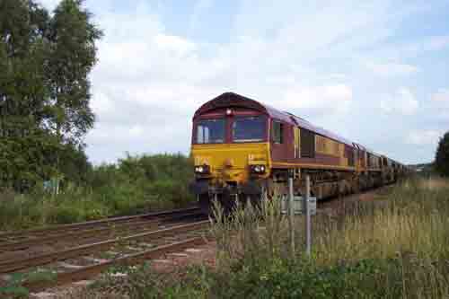
Fig 2- Looking North
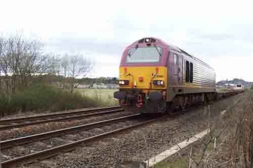
Fig 3 - Looking north
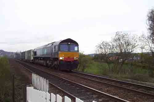
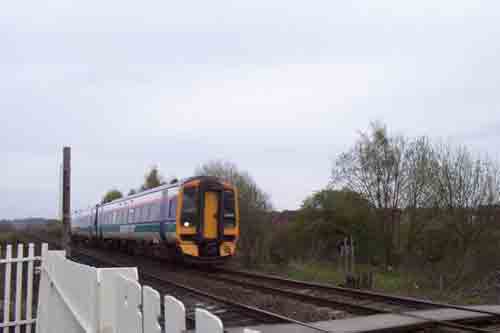
Fig 4 - Looking south
Disclaimer
All information contained within this is site is � Trainspots. The images used on this site remain the property of the original photographer, as credited at the top of the page, and are used with their kind permission.
The information on these pages is supplied for the benefit of railway enthusiasts who carry out a harmless hobby, and through the medium of photography and video, actually promote the railway industry. Railway enthusiasts can also act as eyes and ears against railway vandalism, and as such should surely be encouraged to do so by the supply of adequate information such as is found on this website.
This site has been created to assist railway photographers in their travels around the country. It is based on the personal knowledge and experience. No liability can be held against the web site or its contributions for incorrect information. Trainspots will endeavour to check all information and corrections will be accepted and posted accordingly.
Advice as to the locations general environment is given as a guide on each page. This information is a GUIDE only. ALWAYS be careful with your equipment, Trainspots can not be held responsible for your personal security. Avoid leaving your property on display for all to see, be aware of your surroundings at all times. There are, sadly, people who will not think twice about trying to steal your equipment.
Trainspots DOES NOT condone trespass and none of the information on this site should be taken as a right to trespass on either railway or private land. To the best of our knowledge all locations are publicly accessible areas, where they are not contact information will be given to the appropriate authority for permission to be obtained.
The content of this site is created and intended for all age ranges but the content of sites linked from this site are not subject to the same intentions. Trainspots will attempt to check links for validity but as time passes and the site grows this will not always be possible. Broken, or indeed updates to, links should be submitted to the editor for inclusion in the updates. All links external to the Trainspots site are opened in a new browser window. Trainspots has been running now for over 10 years and there are imitation sites and guides to railfotspots. But we are a free site and we continue on the path we started out on over a decade ago to provide a useful guide to UK Railway Photographic Locations.